Thematic Investigations
Hydrogeologic Setting

The BHRS is located on a gravel bar adjacent to the Boise River 15 km from downtown Boise. The BHRS is just upstream from the mouth of a canyon where the Boise River leaves its high-relief headwater catchment and enters the western Snake River Plain. Deposits at this site are the youngest in a series of Pleistocene to Holocene coarse braided-stream deposits that mantle a sequence of successively older and higher terraces. Outcrop and quarry exposures show coarse, unconsolidated and unaltered fluvial deposits underlain by a clay layer. Geological features
in similar deposits in the area show: massive coarse-gravel sheets; sheets with weak sub-horizontal layering and with planar- and trough-cross-bedded coarse-gravel facies; and sand channels, lenses, and drapes.
Coring

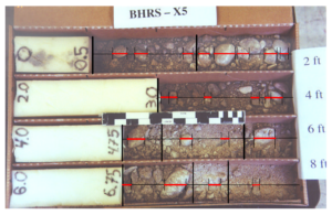
Each well was cored and drilled 1.5 to 3 m into the clay layer underlying the fluvial aquifer during the installation of the PVC well casing and screen. The
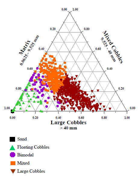
core was examined at 0.61 m intervals with broke into sample intervals based upon changes in lithology, size, shape or relative volume of cobbles, and/or composition and average size of matrix material. Relative volumes of cobbles to matrix were also calculated.
Grain size distributions were found for each interval and included detailed analysis of the cobble and matrix contents for each interval. All of the sample intervals were then classified into one of five lithotypes: sand, floating cobbles, bimodal, mixed, large cobble.
Sources and Further Readings
Barrash et al., 1999. BHRS: Objectives, design, initial geostatistical results.
Barrash & Reboulet, 2004. Significance of porosity for stratigraphy and textural composition in subsurface coarse fluvial deposits, BHRS.
Reboulet & Barrash. 2003. Core, grain-size, and porosity data from the BHRS.

