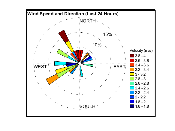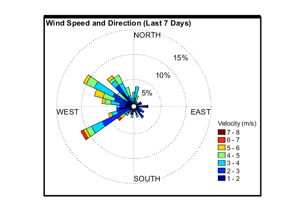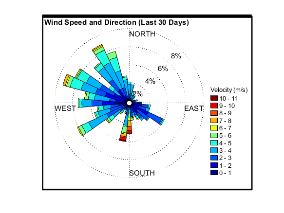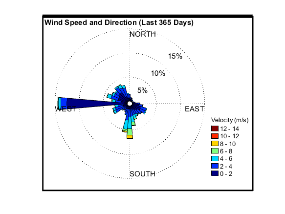
Station Status: Operational, Active Telemetry (MET and Soil Pits 3 and 4 only)
Note: Telemetry may fail during fire season/other.
Recent raw data are telemetered hourly.
Corrected data is available for download in the “Historical Data” tab.
General site description is available in the “Site Info” tab.
For questions or assistance with this data, please contact Dr. Chris Walser
Treeline Data
Site Info
DCEW Site: Treeline Weather
Location (Lat/Long): 43.73019, -116.140143
Elevation: 1610 m
Reporting Since:1999
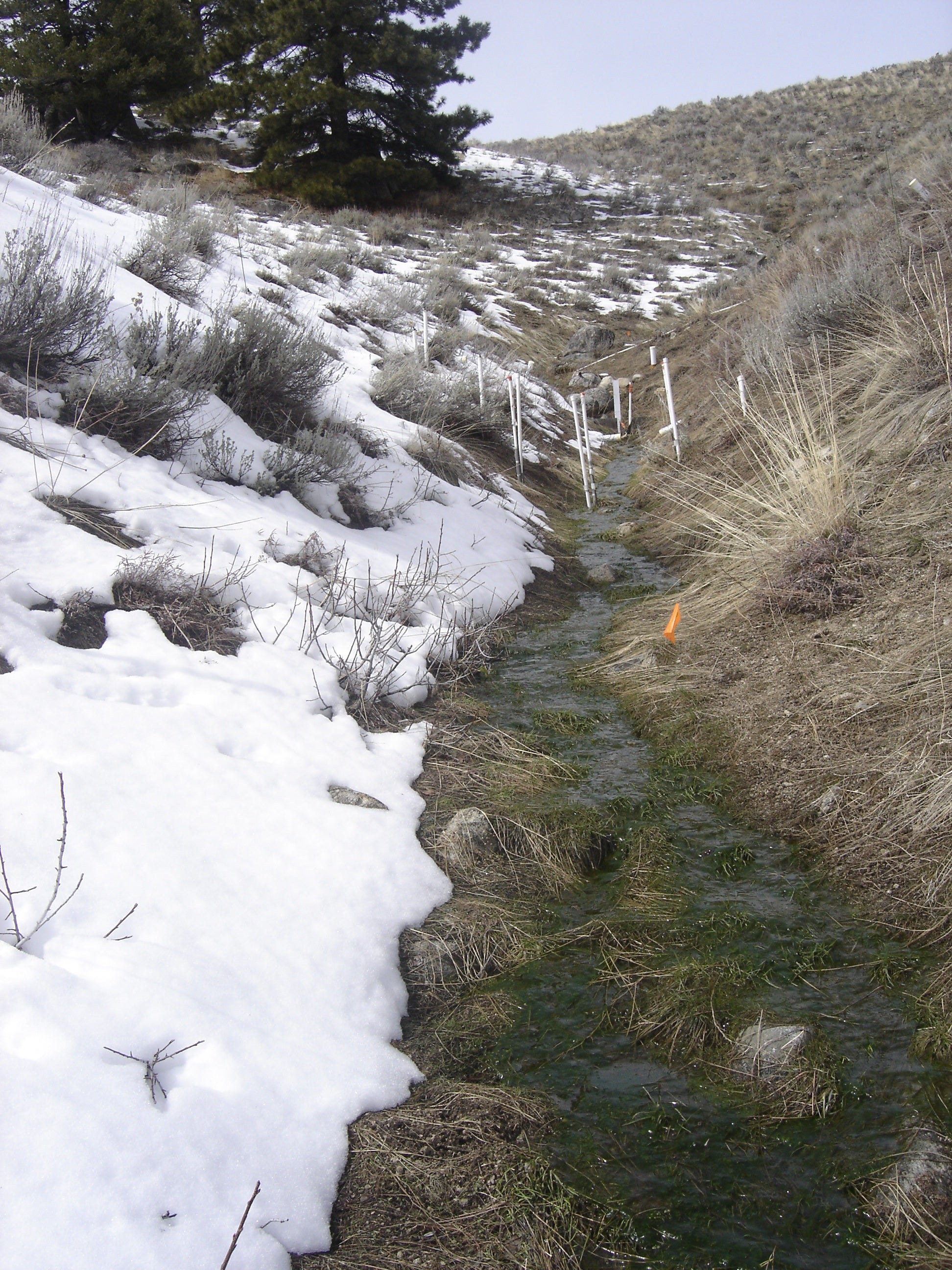
Site Notes: The Treeline site encompasses 0.02 km2 and is located at a mean elevation of 1610 m within the Dry Creek Experimental Watershed (DCEW). Total relief of site is 70 meters. The Treeline site trends northwest to southeast, represents all aspects, and encompasses land surface slopes of 20-40˚ over mostly concave and convex angles. Soils are derived from weathering of the Idaho Batholith, a biotite granodiorite intrusion 75-85 million years in age.
Soils are classified as sandy-loam (Yenko, 2003). Soil depth ranges from 0.25 m-1.2 m and averages 0.45 m. Soil depth is greatest along lower slopes adjacent to the stream channel in the center of the catchment. The primary vegetation includes sagebrush, forbs, grasses, and scattered trees (Pinus ponderosa; Pseudotsuga menziesii), and live canopy cover ranges from 9-11% during fall and winter months and 35-5% in spring and summer seasons.
Precipitation (annual average 570 mm) falls mostly during the cold season, with approximately half the annual precipitation falling as snow. Rain on snow events are common during the late fall and early spring seasons. A persistent snowpack remains from mid-December through March of most years. Winter air temperatures range from 5 to -10 ˚C. Summer months are hot and dry (air temperature ranges from 20-28˚C) with infrequent thunderstorm events. The site is drained by an ephemeral stream. Streamflow typically begins in early fall with the onset of fall rains, but remains low or episodic with the development of the snowpack. Late fall and early winter rain on snow events and/or complete melt on southerly aspects generate small hydrograph peaks. Snowpack on the north facing slope is usually maintained from the onset of snowfall. The annual hydrograph peak usually occurs in March or April depending on the duration of snowmelt.
Instrumentation at the site is currently measuring the following variables: air temperature, relative humidity, solar in and net radiation, wind direction and speed, soil moisture, soil temperature, shielded and unshieded rain gages, and snow depth. Stream flow measurements were established initially in 1999 and operated in conjunction with short term research, periodically through 2007, providing in stream water level and temperature. Another weir was installed October 1, 2007 at an elevation of 1595 m, providing continuous water level, discharge, temperature, and conductivity measurements through 2022. Water samples have been collected at this site seasonally since 2004, initially for major ions, and more recently to include cations and oxygen isotopes. Stream flow at this site is intermittent with flow typically occurring January through June. Soil Pits 3 and 4 continue to operate while Soil Transects North and South were decommissioned in late 2020.
Snowmelt at Treeline, Spring 2010
The following video contains no audio.


